Recent Changes - Search:

add Trips page

hide Trips

Trips


hide Topics

Topics

show Changed

Changed

Visitor's book Site map pmwiki-2.3.37

2022-12-28 St Bathans, Maps

for photos pages for maps page for photos pages for main page for day pages add main page trail

add sub-page trail

2022-12-29 Kōpuwai Conservation Area

Start: 10:30 Start elev: 1,636 m Max elev: 1,643 m Distance: 19.7 km
End: 17:19 End elev: 1,644 m Ascent: 1,056 m Avg moving speed: 3.1 km/h
Duration: 06:49 h Elev gain: 8 m Descent: 1,032 m Duration moving: 06:26 h

Kōpuwai Conservation Area

Nicholsons Hut
Nicholsons Hut

Nicholsons Hut

Nicholsons Hut is a Bivvy or Basic hut, located at -45.353, 169.186. There are 5 bunks with mattresses, toilets - non-flush, water from stream, and water supply. Bookings are not required, usage is first come, first served.
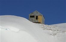
Nicholsons Hut
2022-12-29 11.16.08 S20+ Simon - Nicholsons Hut.jpeg: 9248x6936, 23315k (2023 Jan 17 21:01)
2022-12-29 11.23.10 S20+ Simon - looking out the door of Nicholsons Hut.jpeg: 6928x9248, 15640k (2023 Jan 17 21:02)
2022-12-29 11.24.46 S20+ Simon - Susie in Nicholsons Hut.jpeg: 9248x6936, 12840k (2023 Jan 17 21:02)
Boundary Hut
Boundary Hut

Boundary Hut

Boundary Hut is a Bivvy or Basic hut, located at -45.33, 169.145. There are 3 bunks with mattresses, toilets - non-flush, water from stream, and water supply. Bookings are not required, usage is first come, first served.
Boundary Hut
2022-12-29 13.36.08 S20+ Simon - Susie and Brian descending to Boundary Hut.jpeg: 9248x6936, 25992k (2023 Jan 17 21:02)
2022-12-29 13.37.04 IMG_0704 Brian - Susie and Simon heading down to Boundary Hut.jpeg: 5472x3648, 10944k (2023 Dec 28 12:09)
2022-12-29 13.42.33 S20+ Simon - Susie and Brian bagging Boundary Hut.jpeg: 9248x6936, 22226k (2023 Jan 17 21:02)

2022-12-30 St Bathans Blue Lake

Start: 15:08 Start elev: 544 m Max elev: 616 m Distance: 5.7 km
End: 17:38 End elev: 544 m Ascent: 262 m Avg moving speed: 2.7 km/h
Duration: 02:30 h Elev gain: 0 m Descent: 262 m Duration moving: 02:07 h
St Bathans Campsite
St Bathans Campsite

St Bathans Campsite

St Bathans Campsite is a Basic campsite, located at -44.867, 169.799, set in a rivers and lakes landscape. Access is by campervan, car, and caravan. It has 9 unpowered sites with non-powered/tent sites, water from tap - not treated, boil before use, toilets - non-flush, toilets, and water supply. Dogs allowed. Keep dog under control at all times. Other pets on conservation land rules. are allowed. Bookings are not required, usage is first come, first served.
St Bathans

2022-12-31 Lauder Basin Conservation Area Dunstan Mountains

Start: 08:12 Start elev: 484 m Max elev: 1,659 m Distance: 38.3 km
End: 18:08 End elev: 507 m Ascent: 2,102 m Avg moving speed: 3.9 km/h
Duration: 09:56 h Elev gain: 23 m Descent: 2,084 m Duration moving: 09:48 h

Lauder Basin Conservation Area Dunstan Mountains

Lauder Basin Hut
Lauder Basin Hut

Lauder Basin Hut

Lauder Basin Hut is a Bivvy or Basic hut, located at -44.845, 169.66. There are 2 bunks with mattresses, toilets - non-flush, water from stream, and water supply. Bookings are not required, usage is first come, first served.
Lauder Basin Hut
2022-12-31 12.51.20 Brian -  Lauder Basin Road.jpeg: 5472x3648, 7600k (2023 Dec 28 12:09)
2022-12-31 13.43.28 S20+ Simon - first view of Lauder Basin Hut.jpeg: 9248x6936, 19479k (2023 Jan 17 21:03)
2022-12-31 13.45.20 S20+ Simon - close to Lauder Basin Hut.jpeg: 9248x6936, 29009k (2023 Jan 17 21:03)
2022-12-31 13.46.10 IMG_0715 Brian - Simon heading down to Lauder Basin Hut.jpeg: 5472x3648, 11079k (2023 Dec 28 12:09)
2022-12-31 13.48.05 Brian -  Simon arriving at Lauder Basin Hut.jpeg: 5472x3648, 12801k (2023 Dec 28 12:09)
2022-12-31 14.02.41 S20+ Simon - at Lauder Basin Hut.jpeg: 9248x6928, 17029k (2023 Jan 17 21:03)

2023-01-02 Pisa Conservation Area

Start: 09:31 Start elev: 336 m Max elev: 1,348 m Distance: 18.4 km
End: 17:07 End elev: 378 m Ascent: 1,428 m Avg moving speed: 2.7 km/h
Duration: 07:09 h Elev gain: 42 m Descent: 1,420 m Duration moving: 06:51 h

Pisa Conservation Area


cURL DoC API error: "The requested URL returned error: 404" https://api.doc.govt.nz/v2/huts/100040541/detail?coordinates=wgs84
Deep Creek Hut

2023-01-02 13.44.03 S20+ Simon - Brian arriving at Deep Creek Hut.jpeg: 9248x6936, 25863k (2023 Jan 17 21:04)
2023-01-02 13.44.09 IMG_0726 Brian - Simon arriving at Deep Creek Hut.jpeg: 3648x5472, 11574k (2023 Dec 28 12:09)
2023-01-02 13.44.23 Brian -  Simon arriving at Deep Creek Hut.jpeg: 5472x3648, 12640k (2023 Dec 28 12:09)
2023-01-02 13.45.41 S20+ Simon - Deep Creek Hut.jpeg: 9248x6936, 19295k (2023 Jan 17 21:04)
2023-01-02 13.45.53 S20+ Simon - Brian arriving at Deep Creek Hut.jpeg: 9248x6936, 19005k (2023 Jan 17 21:04)

add sub-page trail

tahi Page last modified on 2023 Dec 30 08:35

Edit - History - Recent Changes - WikiHelp - Search - email page as link -> mailto:?Subject="KiwiWiki: 2022-12-28 St Bathans, Maps"&Body=